Tiwanaku
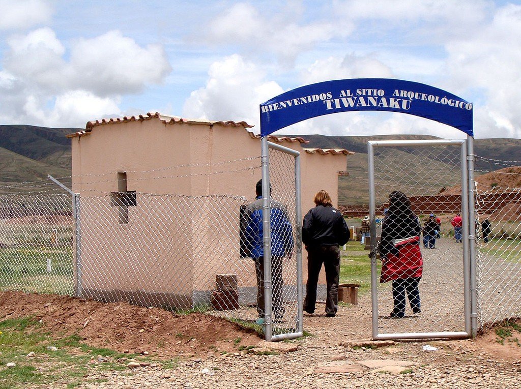
Tiwanaku is an archaeological complex located on the high altiplano plateau, 20 km southeast of Lake Titicaca, La Paz Department, Bolivia. Tiwanaku was inscribed on the UNESCO World Heritage List in 2000 as “testimony to the power of an empire that played a major role in the development of civilization in pre-Columbian America”. Tiwanaku was the center of the eponymous civilization that existed on the shores of Lake Titicaca in the XV-XII centuries BC. It is still a mystery how the aborigines of South America managed to build these structures of stone on a high plateau, as some blocks weigh up to 200 tons. Equally mysterious is the decline of the Tiwanaku culture, which existed long before the Inca Empire in what is now Bolivia, Peru, Argentina and Chile.
Discovery
The city was once called Taipikala – Center of the World, according to other sources, Vignaimarca – Eternal City, but nowadays its name is Tiahuanaco – Dead City.
.It is now believed that Tiahuanaco was the capital of the pre-Inca civilization of the same name, which dominated the Andean region between 500 and 900 AD. The city at its height had about 20,000 inhabitants and covered an area of 2.6 square kilometers. The Tiahuanacan culture itself originated around 2000 – 1500 BC. There is also a point of view that between 300 BC and 300 AD the city of Tiahuanaco was a religious center where pilgrimages were made. Over time, Tiahuanaco became the imperial capital.
.
Although the first explorers of Tiahuanaco believed that it could not have been a major city, but only a “ceremonial center with a small number of permanent inhabitants”. Thus, pioneer American archaeologist Ephraim George Schuyer wrote in 1877, “This area cannot supply food or support a substantial population and is not suitable for the location of a state capital. Tiahuanaco could only play the role of a sacred city, the position of which was determined by chance, prophecy, or dream…”. Even nowadays, the area near Lake Titicaca is hardly suitable for farming by conventional methods. The deplorable state of agriculture in the area today is direct proof of this. But studies have shown that Tiahuanacan agriculture was at such a high level that it could well feed the capital.
.
The lands exposed from the lake’s departed water have characteristic alternating bands of rising and falling soil. It was not until the 1960s that the purpose of these raised bands-platforms and shallow channels-was understood. Visible today, these “waru-waru”, as the Indians call them, turned out to be part of an agrotechnical complex created in ancient times, but “surpassed modern land use systems”. They are now called “raised strips”. In the plain around Lake Titicaca, the inhabitants poured artificial mounds of soil, irrigated using canals between fields.
Work to recreate the system of raised fields has shown that potatoes, for example, grow much better here than when planted normally in dry soil on the plain. At this altitude the main enemy of farmers must be frost, which causes great damage to the crop. In raised fields, the effects of frost are minimized because the water in the canals around them retains the day’s heat and maintains a higher temperature than on the surrounding plain. Crops in raised fields do not suffer either from severe drought or from flooding when neighboring fields are inundated. In the experimental plots the potatoes yielded three times as much as in the most productive modern fields.
For A. Poznanski there was no doubt that Tiahuanaco was the oldest and most significant city of the New World. Here a supreme race ruled, establishing laws and morals that extended as far as Argentina and the southwest of the present-day United States. Tiahuanaco’s coastal location caused the city to prosper.
.
A. Poznanski concluded that Tiahuanaco experienced two disasters – one natural, caused by an avalanche of water, and then some kind of disaster of unknown origin. In Poznanski’s opinion, the direct cause of Tiahuanaco’s demise was the flood, as evidenced by the presence of lake flora (Paludestrina culminea, P. andecola, Planorbis titicacensis, etc.) in the sediment along with the skeletons of people who died in the cataclysm. In addition, bones of Orestias fish from the modern bogas family were found in the same sediment layer. Fragments of human and animal skeletons were also found lying in chaotic disorder along with worked stones, implements, tools and countless other objects. It is evident that all this was dragged, broken and piled up by some force. Anyone who would take the trouble to dig a two-meter deep pothole could not deny that all these bones, pottery, jewels, tools and instruments were gathered and mixed by the destructive force of water combined with the sudden movements of the ground. Layers of sediment cover whole fields of building rubble, and lake sand mixed with shells from Titicaca, crushed feldspar, and volcanic ash have accumulated in enclosed spaces surrounded by walls…
.Alan Kolata, an American archaeologist, anthropologist and ethnohistorian, believes that a natural disaster, but not a flood, caused the fall of Tiahuanaco. Andean glaciers and sediments at the bottom of Lake Titicaca preserve evidence of a long dry period that began in the 10th century and lasted until at least 1300. Water withdrew from the raised strips, resulting in crop failures. As a result, the entire system of imperial power began to collapse and, unable to maintain the urban economy, the people left Tiahuanaco and never returned there again.
.
The first Inca ruler (unless you count the legendary Manco Capac) to visit Tiahuanaco was Maita Capac. The city was already extinct at that time. It was the Incas who called it the Dead City – Tiahuanaco. According to the Spanish chronicler Pedro Cieza de Leon, the early Incas were constantly busy building their court and residence in this Tiahuanaco. Away from the ancient structures of Tiahuanaco during his time there were the Inca inn, and the house where Manco Inca was born. Near them were two tombs of the local rulers of the village. On the sacred island of Titicaca, where, according to legend, Inti brought down the first Inca, Manco Capac and his sister and wife Mama Ocllo, the Incas built “the richest temple, entirely lined with gold bars, dedicated to the Sun, where all the provinces subordinate to the Incas brought offerings of gold, silver and precious stones every year. According to Pedro Cieza de Leon, from the temple of the Sun “the Spaniards at different times took a decent amount” and the treasures are no longer there.
.
However, Garcilaso de la Vega has a different version: “As soon as the Indians learned of the coming of the Spaniards to those lands and that they were taking for themselves all the wealth they found, they threw everything into that great lake.” This is not the case. From the time of the Spanish invasion until relatively recent times, Tiahuanaco was subject to destruction.Excavations
One of the biggest problems in researching the history of civilizations in what is now Peru and Bolivia is the lack of a written language. There are reports that there was writing, but at some time the gods forbade it, and all written objects were destroyed on their orders. And the most important events were reflected in myths and legends, which Indians were commanded to memorize and pass from generation to generation in the form of songs. The remaining written sources on the pre-Columbian history of Peru are the records of Spanish clerics, the essence of which was the study of the mores, customs and beliefs of the people inhabiting them. These records were meant to facilitate the subjugation of the Indians and their conversion to Christianity. However, the information gathered by the priests was often initially misrepresented by the Indians because they were uncooperative. It could be misunderstood by the chroniclers because it was reported in a foreign, unfamiliar language and could be so incredible to the European that his mind refused to understand it and interpreted it according to his usual ideas of world order, etc.
.On Tiahuanaco invaluable information is contained in Pedro Cieza de Leon’s Chronicle of Peru. In 1540 he visited the ruins of Tiahuanaco and recorded the legends associated with it. Also of great interest is the work of Inca Garcilaso de la Vega, “History of the Inca State.”
.
The Spaniards, on the one hand, collected some information that is still used by historians today, on the other hand, they deprived them of something equally important – material evidence. They did enough to destroy the spiritual and material culture of the Indians, converting them to Christianity and looting and destroying their structures and using their stones to build their temples. According to A. Poznanski, most of the blocks that made them up were stripped from the ruins of Tiahuanaco in the early 17th century, when the church in the village of Tiahuanaco was built. “The bronze of the huge bolts by which the stone slabs were joined,” he wrote, “was used in the casting of bells for the same church. Only what was safely covered by the earth and could be found by archaeologists remained in relative preservation after the conquistadors.”At first, Tiahuanaco was indeed securely covered with earth for some time, with only huge vertical pillars and, amazingly, the perfectly level and unbroken Gates of the Sun rising above it. What was most surprising was not even the desolation of this place, but the fact that it was covered with such a layer of soil that it was able to turn into an arable field. But to form a cultural layer of such thickness, you need a lot of people to have lived here for a very long time. But none of that happened. So, indeed, Tiahuanaco was hidden by the gods through some kind of natural disaster. What kind of disaster? Only the Flood fits that role.
On the alluvium deposits A. Poznanski wrote the following: “There is much reason to believe that Puma Punku was almost entirely covered by alluvium deposits that were swept away, particularly during very old prospecting long before the conquista. Later, when the Iberian Peninsula people came to the Altiplano, new excavations in search of hidden treasures were carried out on a large scale. Even later, during the period when the ruins served as a quarry for the construction of a church in the modern village of Tiwanaku, the rest of the sediment that still covered the ruins was removed. Treasure hunters searched even under the huge blocks, such was the burning desire to find riches.” After the sacking of Tiahuanaco in the 17th century, interest in it must have waned and it was left alone for a while. But in any case, for the Spaniards, it was an indigenous heritage that they detested and hated. A change of attitude towards these ruins took place during the War of Independence from Spanish rule (1810 – 1826), when Tiahuanaco and the pre-Columbian past were upheld by the young independence fighters as icons of the new nation. This view is supported by the fact that in 1825, José Antonio de Sucre – first ruling as the liberator of Bolivia and then as president – ordered the Sun Gate at Tiahuanaco to be dug out of the ground and raised as a symbol of the growth of the new nation. These nationalist sentiments were short-lived, and Bolivian Republican intellectuals favored the idea of the innate criminality and inferiority of the native Andeans. Bolivian scholars at this time portrayed Tiahuanaco as a symbol of the past that must be destroyed in order to move on to a more enlightened era.
.
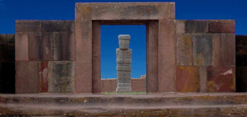
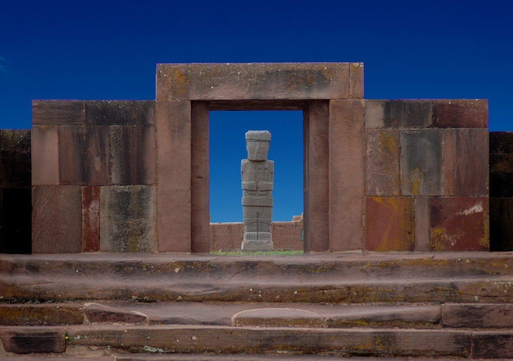
Ephraim Schuyer witnessed this during his visit to Tiahuanaco in the early 1960s. In his book “Peru. Episodes of Travel and Exploration in the Land of the Incas” E. Schuyer writes: “The first thing that strikes the visitor in the village of Tiahuanaco is the large quantity of fine hewn stone in the rough buildings, sidewalks, and fences of the courtyards. It is used as lintels, jambs, seats, tables, and water containers. The church is built largely of it…Everywhere are the remains of antiquities from the neighboring ruins, which were the actual quarry from which hewn stones were taken, not only for Tiahuanaco and for all the villages and churches of its valley, but also for the erection of the cathedral of La Paz, the capital of Bolivia…The monuments of the past have provided the materials for most of the public buildings, bridges, and highways of today.” “Since 1833, however, the iconoclasts have been at work with renewed vigor,” says E. Schuyer. – Unable to dismantle the massive stones that made up the base of the so-called Hall of Justice, they mined them and blew them up with gunpowder, removing many of the carefully carved fragments to line the cathedral of La Paz.” The Hall of Justice was located 250 paces southeast of Acapana, stood on a platform fastened with copper clamps, and had walls of gigantic monoliths. The size of the stones composing it, according to E. Schuyer, was marveled at by Pedro Cieza de Leon. Only a description of the Hall and the architectural and construction wonders that were there, made shortly before their destruction by Alcide d’Orbigny, remains. At Tiahuanaco, the Spaniards even blew up large sculptures to use their pieces as building material. Such a fate befell two huge statues described by Pedro Cieza de Leon: “Behind this hill (behind Acapana – F.Ó.) are two stone idols. They are so huge that they seem like little giants, and it is evident that their appearance and long robes are different from what we see in the natives of these provinces. They seem to have their ornaments (jewelry) on their heads.” These statues were smashed to pieces by gunpowder charges.
.By the early 20th century, attitudes toward Tiahuanaco had not changed. It continued to be associated with an uncivilized past and not only did not try to preserve it, but still sought to destroy it. According to A. Poznanski, there was a “systematic destruction of the ruins of Tiwanaku, a destruction carried out both by the builders of the Guaqui-La Paz railroad and by the Native American contingent of the modern Tiwanaku village, who used the ruins as a quarry for commercial exploitation.”
.
A. Poznanski appealed to Manuel Vicente Ballivian, president of the Geographical Society of La Paz, got legislation to protect Bolivia’s archaeological sites passed in Congress, but it did not work.
Attitudes toward Tiahuanaco changed only as a result of the 1952 revolution, when nationalist leaders came to power. During A. Poznanskioni’s lifetime, they attacked him. But after his death in 1946, they readily accepted his view that Tiahuanaco, as a glorious past, united all Bolivians. In light of this new worldview, important steps were taken by the Bolivian government in 1953 to institutionalize archaeology as part of the task of integrating the indigenous majority of Bolivians into the country’s social life. Archaeologist Carlos Ponce Sanchines was the self-proclaimed pioneer and leader of this movement, according to the idea that national identity was based on the discovery and preservation of a common Andean past. He directed the Bolivian State Center for Archaeological Research on Tiahuanaco (created in 1957) for the next four decades and published several essays, articles and books. To this day, he is still considered the most influential expert in Bolivia on the archaeology of the Tiahuanaco. C. Ponce and his team of archaeologists took on the task of restoring the Temple of the Stone Heads and Calasasaya (1960s)..
At the same time, an indigenous movement for political and social power began to gain momentum, asserting its need for an autonomous Amerindian cultural identity. Rejecting the nationalists’ idea of incorporating Amerindian peoples into Western society, Bolivia began to build a new model of Bolivian national identity, in the multi-ethnicity of Amerindian peoples, and Tiahuanaco became a symbol for the indigenous movement. In 1992, the United Confederation of Labor Peasant Unions of Bolivia organized protests across the country to commemorate the five hundredth anniversary of Spanish colonialism in the Americas. As part of these protests, the Aymara held a symbolic takeover of Tiahuanaco and proclaimed it the capital of their new state. Upon coming to power, Bolivian President Evo Morales, whose two Aymara inaugurations were held at Tiahuanaco, promised that excavations at the complex would continue. However, the work now underway at the Tiahuanaco site is unlike an archaeological excavation.
.
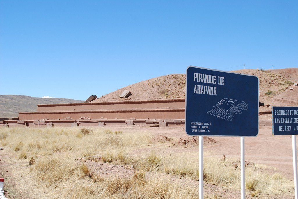
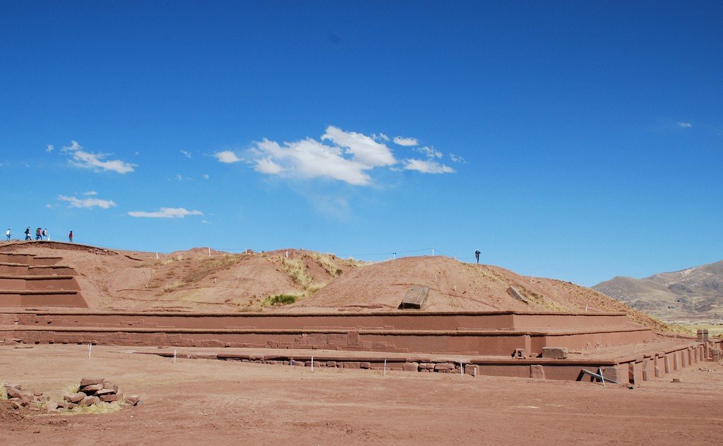
In 2000. “the ancient city of Tiahuanaco” as a “spiritual and political center of pre-Hispanic Amerindian culture” was recognized by UNESCO as a World Heritage Site. But the condition of the complex is of great concern to the UNESCO World Heritage Center. In March 2010. The World Heritage Center expressed deep concern to the Bolivian Minister of Culture about the improper implementation of the three-year “Conservation and Preservation Project for Tiwanaku and the Acapana Pyramid” funded by Japanese extrabudgetary funds. The Center is dissatisfied with the management system of the complex and in particular the museums, the lack of reinforcement of the Akapana pyramid, the deterioration of the conservation of the archaeological collections of the museums, the lack of planned archaeological excavations and the actions of the municipality taken without the approval of the Ministry of Culture, which is necessary given the status of Tiahuanaco as a World Heritage Site..The study and restoration of the archaeological complex of Tiahuanaco, leave much to be desired. And it is no secret that construction in Tiahuanaco is being done mainly to generate income from tourism. And tourists are not interested in looking at the ruins, so the main object of the complex – the Akapana pyramid should be rebuilt as soon as possible. According to the then Bolivian Minister of Culture Pablo Grue, who justified the unacceptable quality of work in Acapana, 5 years ago there was just a hill, and now (2009) – something resembling the original structure.
.Journalists covering the problems of Tiahuanaco call the restoration of Akapana an “archaeological travesty” to attract tourists, writing that the makeover of the pyramid may cause Tiahuanaco to lose its status as a cultural heritage site. The steps of the pyramid are covered with brick (most likely adobe) and then plastered, whereas ancient builders used hewn stone. Of course, the result should be called a new-deal and condemned in every possible way. But we should not forget that stone facing of the pyramid was lost, and extraction, delivery and processing of a stone is an expensive pleasure, moreover in mountains. Besides slabs weighing much, it is necessary to lay. We must realize that we will never get that work of the highest construction art, performed with the help of the gods. It is unlikely that the indigenous people hired for excavations and construction in Tiahuanaco will be able to repeat or at least come close to what is impossible to do even with the latest technical developments. The low-budget method of “restoration” of the Akapana pyramid could undoubtedly be turned a blind eye after complaining a little. But the worst is that, according to the testimony of Señor Jose-Luis Paz its construction is being carried out in the manner of “free-hand with the design.”
.
Still, it must be said, to use the words of E. Schuyer, that Tiahuanaco, even “being a tweaked looted ruin, still has ample evidence of former greatness.”
.The three periods of construction of Tiahuanaco
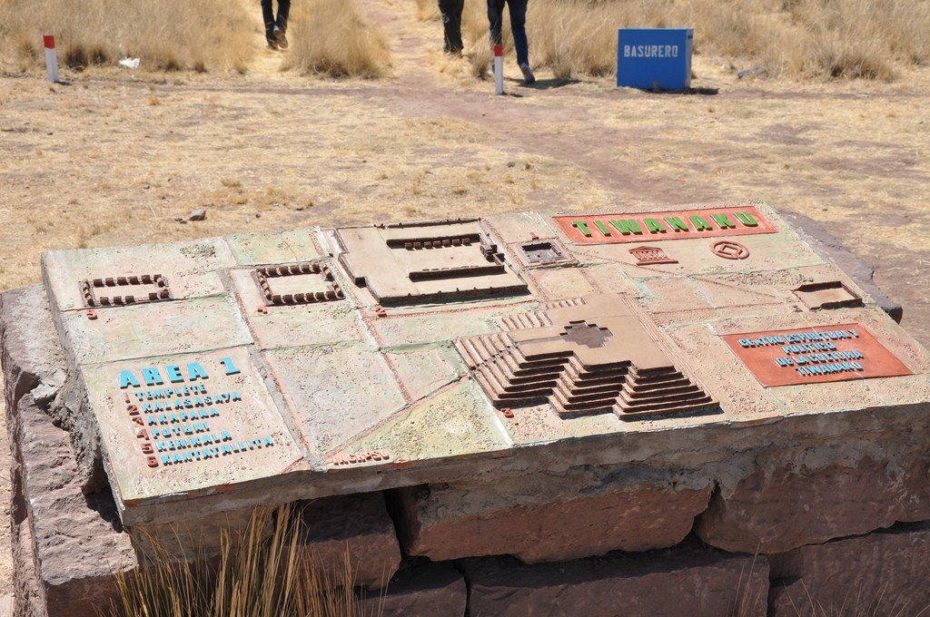
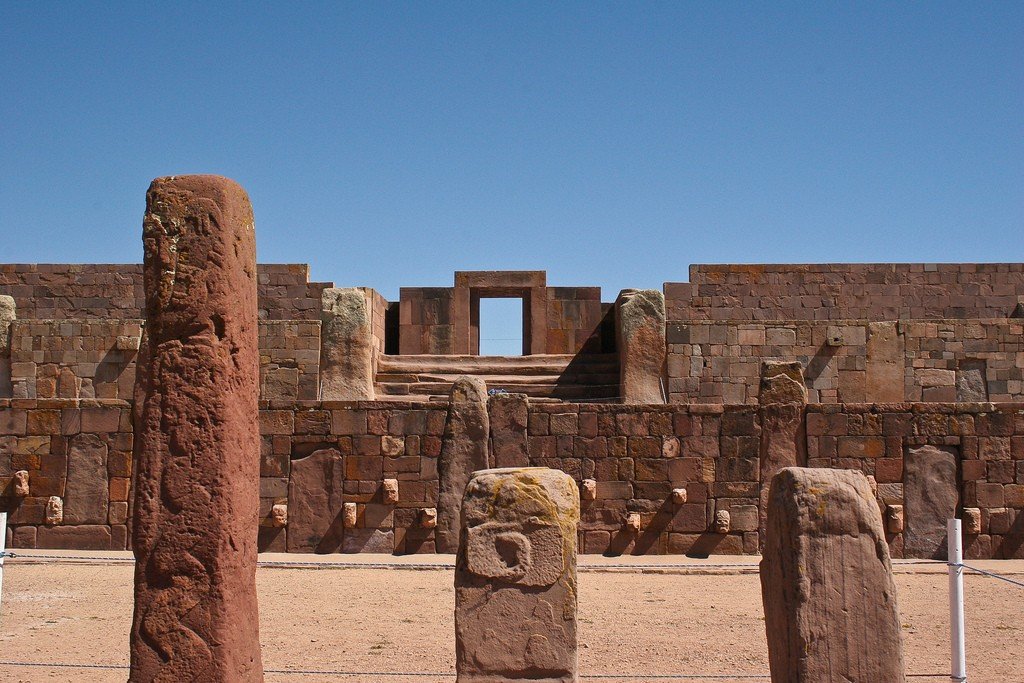
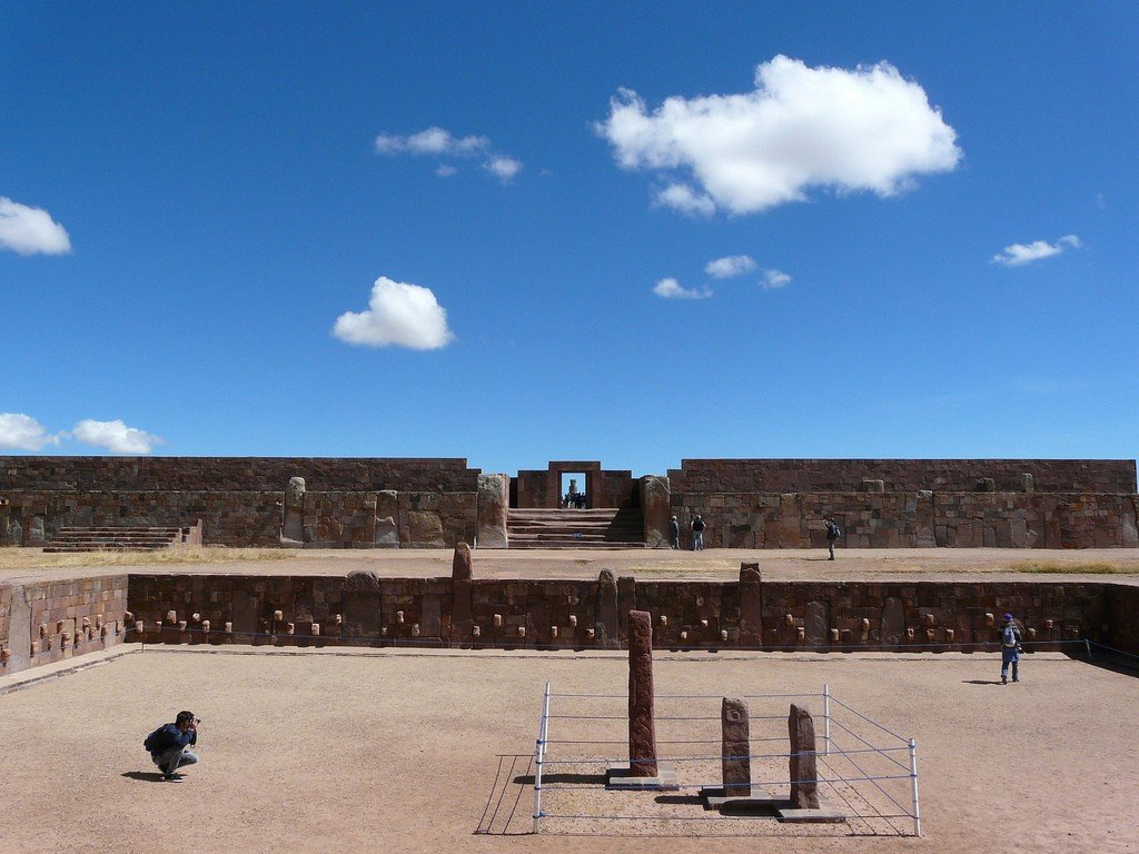
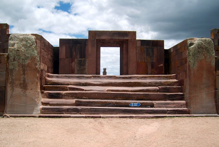
As is well known, A. Poznanski distinguished three main periods of Tiahuanaco. To the first period he attributed “as a building exclusively of this period” the Temple of Stone Heads. Then the construction of the Akapana pyramid and the Temple of the Moon (Puma Punku) was begun. The construction of Akapana and Puma-Punku was continued in the second and third periods. Kalasasaya was laid out in the second period and was completed, reconstructed and repaired in the third period. The large porch of Kalasasaya belongs to the second period. Its inner temple, the sanctissimum, and the Gate of the Sun were built in the third period.
.
Of the building materials in the first period, sandstone was used exclusively, which came from the mountainous areas south of the ruins. Lime tuff was used for some works (the sculptures of heads set in the temple walls).
.
Andesites were used in the second period, albeit on a small scale. In addition, in the second period, the Tiahuanacans used sandstone monoliths from temples of the previous period, remodeling them “according to their own measure, with their new style and symbolic decoration.”
In the third period, everything was made exclusively of solid andesite lava, such as the balcony wall and reconstructions of the second period. Andesite blocks were mined in areas very far from the ceremonial center.
Thus, bronze appears in the third period. Repairs in the walls of earlier periods are often noted, during which they connected the blocks with bronze bolts; they used them in various forms of their own designs, even in the form of a ring. There is an opinion that the connecting parts for repairing blocks, on the contrary, were not made in advance, but that molten bronze was poured into the recesses made and, solidifying, fastened the blocks together and took the outline of the recess. However, the convex shape of the connecting elements casts doubt on this assumption.
.
A. Poznanski emphasizes the astronomical knowledge of the Tiahuanacans: “Among the sciences they knew… they mastered the astronomical aspects of the meridian, with the help of which it was possible to accurately determine the “amplitude” of the sun in the third period and with this, in turn, the tilt of the ecliptic – a value that provides us with a basis for determining the approximate age of Tiwanaku. With this knowledge the equinoxes and solstices were established, the aphelion and perihelion were known, and the solar year divided into twelve months was utilized. Even the zodiac became known…but in a form differing to some extent from the known pattern of the ancient Semitic sages of Chaldea, whose knowledge has passed into the astronomy of today.”
.Time of Origin
In the early 20th century, Arthur Poznanski discovered that the astronomical orientation of the temple did not correspond to the tilt of the Earth’s axis in modern times, which is 23.5 degrees. Using archaeoastronomical theories then just published by Sir Norman Lockyer, as well as formulas presented at the International Conference of Astronomers in Paris in 1911, Poznanski dated Tiahuanaco to approximately 15000 B.C. These results aroused interest, and in 1926 the German Astronomical Commission, which included Dr. Hans Ludendorff, Dr. Arnold Kohlschutter, and Dr. Rolf Muller, was sent to Tiahuanaco. They confirmed Poznanski’s conclusion that Kalasasaia was an astronomical and calendrical laboratory, but the time of its construction was determined to be either 15000 or 9300 B.C., depending on the assumptions made. depending on the assumptions made. A. Poznanski speaks of other aspects that, although not astronomical, confirm and strengthen the assumption of extreme antiquity of the capital of the American man. They are as follows:
.1. It is evident beyond doubt that the inhabitants of Tiwanaku knew the now extinct animals which they reproduce accurately by stylizing them on pottery and other sculptural works. This fauna may have disappeared at the end of the last period of glaciation on the Altiplano, as the alluvial layers show.
2. Some human skulls found in the deep layers of Tiwanaku are completely fossilized.
.
3. One of the decisive proofs of the age of Tiwanaku man is underground habitation. In this age, especially in the first period, they did not build houses; their temples were semi-subterranean buildings. This primitive custom persists in the second and third periods, in which even that ruling class, who lived on an island surrounded by a moat, lived in tiny houses where they lived and slept in squats. Up to this time four of them have been found in almost unaltered form, and two more have been found before our research.”
.
4. Another of the factors that influenced human development at Tiwanaku is climate. Had this capital city been built at the altitude above sea level as it is today, the climate would have been harsh and unsuitable for human life, as is noted at the present time, with its atmospheric phenomena, which are so unfavorable to the development of agriculture and stock-raising. Under such circumstances it would have been impossible to achieve extremely high population densities, as was the case in past epochs. The climatic belt has changed from the period of the apogee of this civilization to the present. The northern part has risen and the southern part has undergone a great fall.
5. The fauna and flora have changed radically from the age of greatness to the present time. This can be proved by the remains of marine fauna now found in Lake Titicaca and in the clays of the subsoil of Tiwanaku.
.6. It is certain that the great Andean lake was formed by the melting of the glaciers that existed in the second and third periods, and that in the preceding period this lake was very small-much smaller than at the present time. On its shores exist structures created by human hands, which were revealed by the huge and final diminution of the lake. A completely eroded block – at one time also carved … on which the sun rises on the day of the winter solstice.
.7. The destruction of the blocks of the first period, which are composed exclusively of red sandstone, and their very primitive sculpture of calcareous volcanic tuff, shows abrasion lasting for several thousand years. This is a fact, despite the fact that perhaps also for thousands of years they lay covered by alluvial sediments which were later, little by little, washed away by the torrential rains which for the most part opened them up. Even the very hard andesite lava blocks of the second period, especially on the east façade of Calasasaya, show considerable wear by erosion, particularly the two monolithic blocks on the sides of the porch, although they were covered with earth before 1903
.8. The glacial Andean lake, or, as d’Orbigny calls it, the “inland sea,” certainly reached in the second period, and certainly in the third, the boundary of the Tiwanaku monuments. This assertion is proved by the presence of many hydraulic structures, such as wharves, canals, and especially the spillway by which the network of canals diverted the water.
9. A southern tilt of the continent of this kind can only occur as a result of geotectonic factors caused, in turn, by the cessation of high pressure (ice) on the part that made up today’s Altiplano.
.10. By analogy, we can conclude that the last ice age occurred in the Southern Hemisphere at the same time as in the Northern Hemisphere, as there is no atmospheric or cosmic factor that we have been able to detect that could have prevented it.
.11. The true cause of the last ice age, as well as the previous one, is still questionable, but the conclusions of most studies show that it occurred simultaneously in both hemispheres, excluding the low-level equatorial regions. The chronology of the ice age in northern Europe has been studied and determined accurately through the researches of Prof. Gerard de Geer, and especially through his studies of the layering of glacial clays (Varven) carried out in Sweden. The latter gave a figure of 6900 B.C. for the end of the Ice Age and 12600 B.C. for the end of the Danish Ice Age. Since the southernmost ice age of Sweden or parallel to Central Europe occurred about 13,000 to 15,000 years ago, by analogy we can judge that the same thing happened in the same latitudes and at the same level relative to the sea in North and South America.
.
Nevertheless, in some parts of the South American continent this climatic phenomenon took place differently; this is especially true for those regions that in the recent geologic period had already a significant altitude above sea level, as was the case in the large expanse of territories, plateaus and lakes enclosed between the two Andean mountain ranges, the Cordillera Marítima and the Cordillera Real, which had already risen to a significant altitude since the Tertiary period and were, moreover, in relative proximity to the equator. The Bolivian Altiplano, for example, the prehistoric site of the greatest culture of the Americas, did not have the great altitude it has today, because of its proximity to the equator it did not experience an ice age as long as the territory of modern Argentina. For this reason, it gave refuge to human cultures much earlier than other parts or during the period when Argentine territories were still covered by continental ice, which at the present geologic moment and a few thousand years later went to Antarctica. It has been proved through the researches and conclusions of famous authorities in modern geology and geography, especially by the monumental labors of Prof. Albrecht Penck, former director and founder of the Oceanographic Institute in Berlin, that the continental ice of Europe exerted a tremendous pressure on the lands on which it lay. As a result, these lands sank, and after the glacial masses melted and descended from these areas, the areas freed from their weight rose again.
.
This same phenomenon of the uplift of territories – after being freed from cover or glacial weight – undoubtedly took place on the Altiplano in Bolivia in a much more intense form than in other parts of the world, owing to the fact that it was at a considerable altitude and in relative proximity to the equator. Because of this great altitude the climate, after the Tertiary period, was never hot, and because of this same slight uplift – certainly not so pronounced as at the present time – and because of its proximity to the equator this glacial period lasted a much shorter time there than in other lands of the South, therefore great human cultures could develop there in a relatively remote period (the first period of Tiwanaku) which probably did not yet exist in a similar stage of development in other parts of our planet. When the great Andean Lake was formed at the end of the last ice age, the following phenomenon occurred: the ice melted first in these areas in relative proximity to the equator and the tremendous pressure or weight that lay on the mountain ranges and high plateaus of the Andean regions disappeared very gradually. Then these areas began to slowly rise, while areas to the south, such as Argentina, because of their distance from the equator, still held for a long time the huge covers of ice that these regions had… Thus century after century the northern part of the present Altiplano and the mountain ranges rose as a result of the cessation of the aforementioned ice pressure, and then the initial tilting that drained the water of the first great glacial lake occurred. In the light of what has been said, it is very difficult to think that human culture on the Altiplano and the construction of its magnificent capital belong to a relatively recent epoch.
.
12. One piece of evidence with which we can strengthen our assertion concerning the great age